1930s Mapping Project

Hi, friends! Welcome back to Stillwater! I hope that your school year has gotten off to a great start and you are getting settled into your routine. With the start of school comes the start of work, and these past few weeks I’ve picked up a project that I began in December of 2018.

In previous blog posts, I’ve talked about working with the Oklahoma Agricultural and Mechanical College yearbooks. At the end of these books is an advertisement section which lists many drug stores, grocery stores, clothing cleaners, doctors, and dentists found in Stillwater. I was curious to see what could be learned about Stillwater in the 1930s through a visual representation of these locations.

I came up with this idea in December of 2018 and I began to list the advertisements in an excel sheet. There were some discrepancies in the yearbooks. For instance, some of the yearbooks did not list an address for a specific business while the same business would list an address the follow year. Through listing the advertisements from each year in an excel sheet, I could correct these discrepancies.  

After taking a semester’s hiatus from this project, I began working on it again in July. Using a map of Stillwater from 1929, I located the addresses and marked them on the map with a small sticky note. The map was fairly detailed and I was able to place the business rather accurately. While this created a neat, and colorful, visual representation, it was not terribly practical for sharing with the world. 

Enter, My Google MapsMGM is a lesser known feature on Google which allows you to drop points and draw lines on Google maps. I added points onto the map to represent the addresses and drew the outlines of the physical Stillwater map onto the Google map. It was difficult to drop the points and draw the lines approximately because Google maps was more modern and lacked specific building names. Moreover, some roads in Stillwater had changed since 1929; in the 1929 map, some of the roads on the east side of Stillwater were listed as dirt roads.

This is an image of the map I created in MGM. Each numbered dot represents a business and the purple lines are where the 1929 map ends.

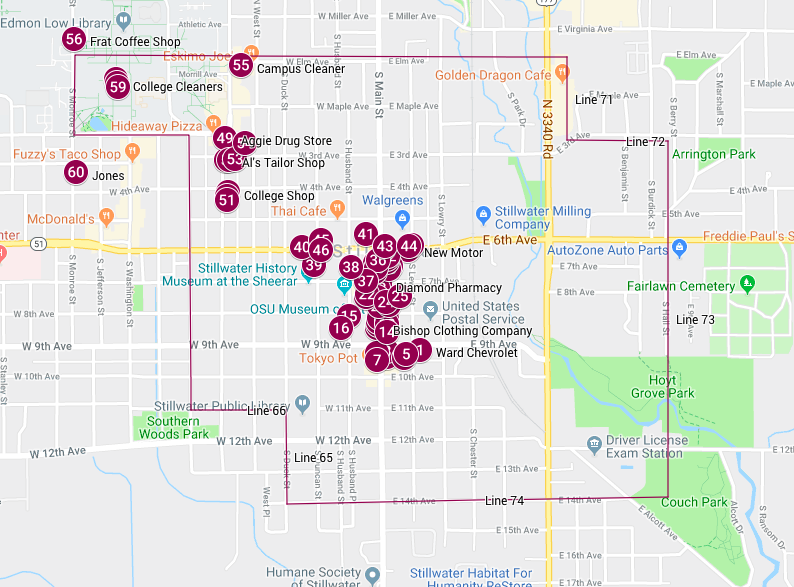
After completing this section of the project, my supervisor helped me to export the map to ArcGIS. ArcGIS will allow me to customize my map more and make it more user friendly. I hope to be able to share that soon!

-Claire Ringer

Williams Hall Recreation: Update

My time with Revit is coming to an end and although I gained an enormous amount of knowledge from this program, it was no easy feat. Learning Revit was a difficult task, as I mentioned in earlier blog posts (link to other blog posts), once the project was close to completion, the frustration and confusion I felt throughout the reconstruction process faded away and morphed into confidence.

Continue reading “Williams Hall Recreation: Update”

Historical Reconstruction Project

As part of the digital humanities internship experience, I was assigned to reconstruct one of Oklahoma State University’s (OSU) demolished buildings, Williams Hall. Williams Hall was built in the early 1900’s, before the rapid modernization which occurred in Stillwater, Oklahoma. Williams Hall initial function was the library, and it was actually the first library on OSU’s campus.

Ivy
Williams Hall


Continue reading “Historical Reconstruction Project”

Historical Reconstruction

Have you ever wondered what an old building previously looked like? Have you ever seen pictures of a building and thought “wow, I wish I could see that”?  Historical reconstruction is the recreation of the building based on blueprints, pictures, books, and other archival materials.

The problems that face reconstructing a historical building is that preservationists claim that reconstructing a building is unethical and more detrimental to the historical value of the building; Some historians agree with this stance, but it is inevitable for a historical building (since they are incredibly old) to either be destroyed, altered, or receive a complete remodel.

(Daria Kareeva and Valeriya Glazkova, “Reconstruction and restoration of historical buildings of transport infrastructure” IOP Conference Series: Earth and Environmental Science, 1-7)

With the rise in technology, people are utilizing the 3D elements and archival material via libraries (such as the Oklahoma State University Library Archives) to reconstruct historical buildings.

Examples of virtual historical reconstruction:

Trinity Chapel-Revit

Project Soane